PANGEA: Make Maps From Photographs
PANGEA combines supported saved photographs into a georeferenced photo map. Start with the included teaching images, then try photos from a MIMIC flight or a camera with the required pose and calibration information.
Mapping terms | MIMIC flight | GCS map tiles
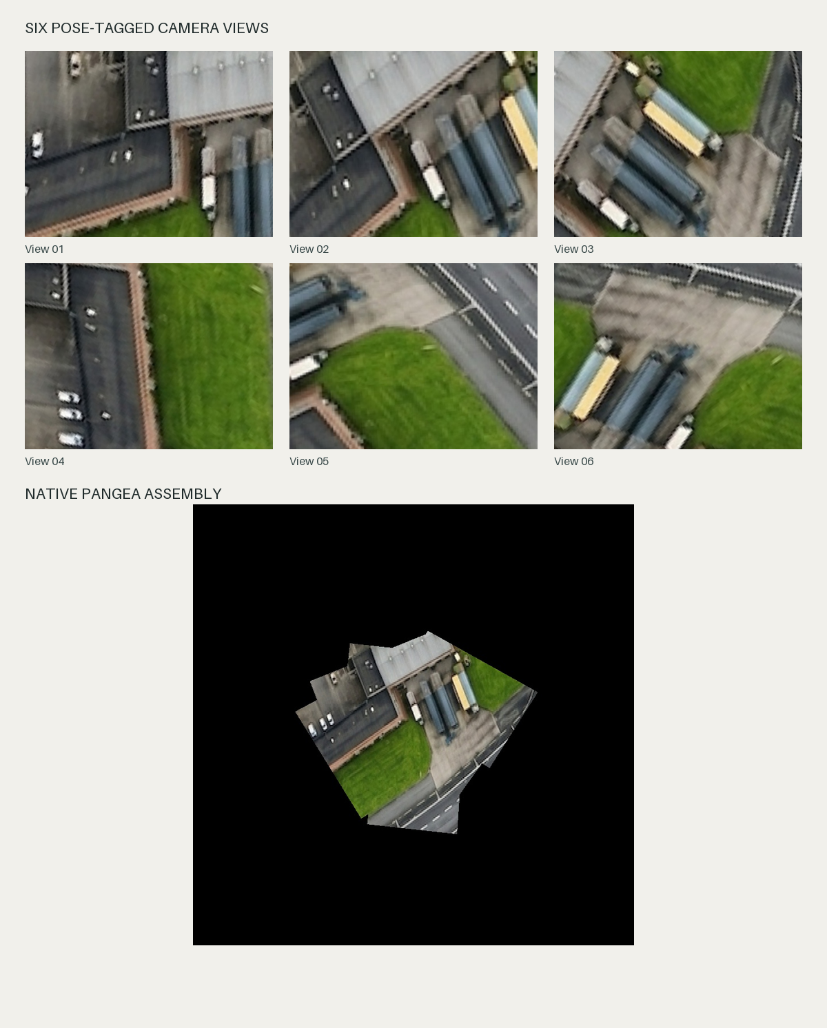
The map is assembled from the six saved camera views.
Try It Without A Flight
From the Sensoraia root, build PANGEA and copy the teaching images into your own example directory:
make -j32 pangea
mkdir -p "$HOME/Pictures/pangea-example/photos"
cp modules/pangea/docs/images/pangea-photo-*.jpg "$HOME/Pictures/pangea-example/photos/"
bin/pangea --input "$HOME/Pictures/pangea-example/photos" \
  --output "$HOME/Pictures/pangea-example/map-01"
Use a new output name for a separate experiment. Wait for the map-published
message, then open map-01/latest/map.jpg. The originals are unchanged.
No flight, physical camera or online map connection is needed for this example.
Make A Map During A MIMIC Flight
The MIMIC Center session starts capture and mapping together and prints a new map directory. PANGEA uses saved camera views, not direct stitching of the source provider tiles.
For a setup where you manage the other simulation components yourself:
Do not run that command beside a session already owning USHER. A missing map does not necessarily mean capture failed; inspect the saved originals and the mapper's own diagnostic.
Use Your Own Camera Photos
For original USHER JPEGs with a matching measured camera profile:
bin/pangea --input /absolute/path/photos --output /absolute/path/new-map \
  --camera-profile /absolute/path/camera.ini
Add --watch if the directory will receive more completed photos. Otherwise
the command finishes its backlog and exits. One camera, resolution and
calibration belong together in a map.
The profile declares delivered image dimensions, lens geometry and mounting.
Use the supplied examples/pangea/aicam-2028.ini only as an illustrative
starting format, not measured calibration. Generic GPS-only JPEGs may lack
the attitude/height evidence required by this workflow.
Prepare The Camera Profile
Copy examples/pangea/aicam-2028.ini to your own camera.ini. Its fields
describe the delivered JPEG, not just the sensor's advertised size:
| Field | What To Supply |
|---|---|
filename_prefix |
Original camera filename prefix, normally a, c or l |
width, height |
Actual JPEG dimensions in this mode |
fx, fy |
Focal lengths in image pixels, not millimetres |
cx, cy |
Principal point in the delivered image |
mount_roll_deg, mount_pitch_deg, mount_yaw_deg |
Measured mounting relative to the aircraft |
Keep schema=PANGEA_CAMERA_V1. The supplied numbers are a nominal example;
substitute measured geometry and mounting for your setup. Changed crop,
resolution or optics can need a different profile. Use original upright
photos, not pre-undistorted, cropped or annotated review copies.
For a live supported camera launcher, choose the actual backend and profile:
This is real capture. Review sensor ownership and service selection first. The visual-return LOOM profile is not this launcher's real-photo mapping mode.
Completed-Survey Workflow
Use a validated capture manifest or survey CSV with the supplied
examples/pangea/survey.ini format. Set input and new output paths for your
survey, then check it before running:
| Choice | Use It For |
|---|---|
| SIMPLE | A simpler reference-plane composite on a desktop |
| GREAT | Seam selection, blending and completed XYZ tile output |
runtime.profile=auto |
Let the application select the supported resource profile |
The bounded profile supports GREAT XYZ output; SIMPLE and orthomap exports use a desktop profile. Do not force a desktop workload onto a small board. Choose the tile zoom explicitly; higher zoom does not create source detail.
Incremental GREAT
This workflow publishes provisional XYZ revisions as completed photos arrive, then produces a final tile pyramid. It is distinct from the ordinary live photo-map watcher and can run independently of USHER.
Copy examples/pangea/great-aicam.ini to your own session.ini. Set:
input.photo_directoryto the original USHER photo directory.input.camera_profileto your matching camera profile.- Start/end latitude/longitude to the region the photos actually cover.
mosaic.reference_plane_amsl_mto ground height in the same vertical reference as the admitted camera altitude; do not mix MSL and ellipsoid heights.output.directoryto a new map session.
Keep runtime.profile=low_memory for this AI-camera directory workflow,
including when trying it on a desktop. The completed-survey profile choices
above are a different input path.
The example chooses pose_policy=recorded for ordinary request-pose metadata.
Choose exposure only when native capture provides qualifying observation-
time evidence. Exposure mode rejects missing evidence rather than silently
using a request pose. Neither choice certifies accuracy.
Follow Completed Photos
Start capture separately, then run mapping in another terminal:
This directory mode accepts completed top-level AI-camera a*.jpg originals
with suitable metadata, not LOOM references or arbitrary GPS-only exports.
Do not edit published originals while mapping. PANGEA reports rejected files
and resource delays; starting a watcher does not promise an immediate revision.
Timing Controls
The incremental follower reads these settings from the session INI:
[live]
update_seconds=30
batch_photos=4
cpu_percent=20
pause_file=mapping.pause
final_file=capture.complete
After the initial revision, changed input becomes eligible for another render
when either four photos have accumulated or 30 seconds have elapsed since the
last successful render. These are scheduling thresholds, not completion
deadlines: validation, preparation and rendering still need time to finish.
cpu_percent limits average process CPU use relative to one core, not the
percentage of the whole computer. Its accepted range is 1..100.
Marker paths are relative to the INI directory. Create the pause file to defer processing, then remove it to resume. Create the final file only after capture and photo publication have finished. Pause and low-memory waits remain cancellable; a final marker does not override a pause.
The ordinary --watch photo-map path instead checks for two seconds of stable
file identity using a monotonic clock, then publishes changed maps on its
ten-second export cadence. A future-dated photo does not postpone admission;
an explicit --since cutoff still filters source timestamps.
Finish Or Resume
Stop capture and let pending tagging/publication finish. Stop the follower with Ctrl+C, then finalize the unchanged session:
For an interrupted run, repeat --follow-great with unchanged inputs/settings.
Stopping PANGEA does not stop USHER. A finalized session is closed; choose
a new output directory for another flight. Directory input uses GREAT's
update/follow/finalize commands, not the completed-manifest --run path.
Create Map Tiles For A GCS
Ground control stations display slippy Web-Mercator (EPSG:3857) pyramids of
256 x 256 tiles addressed as {z}/{x}/{y}.jpeg, with x increasing eastward
and y increasing southward.
The quick --input ... --output ... replay command above writes one stitched
latest/map.jpg (plus latest/map.vrt for GIS tools), not a slippy tile tree.
To generate GCS-ready {z}/{x}/{y}.jpeg tiles from a directory of area photos,
use processing.mode=great with output.format=xyz. PANGEA projects each
admitted photo onto a UTM working grid, selects graph-cut seams, blends
overlapping views across four frequency bands, resamples into Web Mercator, and
writes clean 256 x 256 JPEGs without EXIF or XMP overhead.
Choose Tile Zoom Levels And Staging Output
One XYZ run builds up to three consecutive zoom levels (min_zoom within two
levels below zoom), deriving each lower zoom from aligned 2 x 2 child tiles
so seams never jump when zooming in the GCS:
| Zoom | Ground Pixel (Equator) | Ground Pixel (~52°N) | Typical GCS Use |
|---|---|---|---|
17 |
~1.19 m | ~0.74 m | Approach and circuit overview |
18 |
~0.60 m | ~0.37 m | Standard flight-plan view; also read by MIMIC |
19 |
~0.30 m | ~0.18 m | Maximum built-in zoom of standard GCS satellite layers |
20 |
~0.15 m | ~0.09 m | Near-native low-altitude detail with a custom local GCS layer |
Pick zoom to match your camera's actual ground sample distance rather than
oversampling beyond optical detail. Always set output.directory to a new
staging directory first—never directly to a populated GCS cache—because
PANGEA refuses to overwrite existing {z}/{x}/{y}.jpeg files.
Example 1: Directory Of Just-Captured USHER Camera Photos
Suppose you have just flown over an area with USHER AIcam and copied the folder
of saved a*.jpg originals to $HOME/Pictures/area-flight-01/photos, together
with your matching camera.ini (Prepare The Camera Profile).
Create $HOME/Pictures/area-flight-01/gcs-camera-tiles.ini from
examples/pangea/great-aicam.ini:
[input]
photo_directory=/home/you/Pictures/area-flight-01/photos
camera_profile=/home/you/Pictures/area-flight-01/camera.ini
pose_policy=recorded

[start]
lat=52.0052
lon=4.3574

[end]
lat=52.0034
lon=4.3616

[processing]
mode=great

[runtime]
profile=low_memory

[mosaic]
reference_plane_amsl_m=0.2

[tiles]
zoom=19
min_zoom=17

[output]
directory=/home/you/Pictures/area-flight-01/xyz-session
format=xyz

[live]
cpu_percent=100
Key settings for a folder of photos you already captured:
[start]and[end]: Opposite latitude/longitude corners bounding the area your photos cover.mosaic.reference_plane_amsl_m: Ground height of the surveyed field in the same vertical reference as the flight controller's navigation altitude.runtime.profile=low_memory: Required for the AI-cameraphoto_directoryinput path even on a desktop PC. Settingcpu_percent=100under[live]removes the background 20%-of-one-core throttle when running post-flight on a workstation.
Because all photos are already in the directory, you do not need to run the
--follow-great watcher. Run one of these single-pass commands from the
Sensoraia root:
- Irregular flight path or partial bounding-box coverage — publish every
strictly observed, 100%-covered
256 x 256tile and omit unphotographed corners cleanly without gap invention:
- Complete lawnmower box coverage — finalize the session with graph-cut
seams, multiband blending and source-derived gap completion across the entire
[start]..[end]rectangle:
Both commands publish the slippy tile pyramid at:
Example 2: Completed Survey Directory With Manifest Or CSV
When your photo directory contains a completed capture manifest
(*.capture.ini, which already supplies [start], [end] and source_csv)
or a validated survey CSV (*.csv) beside the JPEGs, use the desktop-capable
survey runner based on examples/pangea/survey.ini.
Create $HOME/Pictures/area-survey-01/gcs-survey-tiles.ini:
[input]
capture_manifest=/home/you/Pictures/area-survey-01/photos/photos_session.capture.ini

[processing]
mode=great

[runtime]
profile=auto

[tiles]
zoom=20
min_zoom=18

[output]
directory=/home/you/Pictures/area-survey-01/xyz-staging
format=xyz
jpeg_quality=95
If you use source_csv=/path/to/photos.csv instead of capture_manifest, add
[start] and [end] corner coordinates; on a desktop PC (profile=auto or
desktop), you can also add complete_only=1 under [tiles] so flight lines
that miss the corners of your [start]..[end] box publish all complete tiles
and record omitted edge tiles instead of stopping.
Validate the inputs and tile plan first, then render across your PC's CPU cores:
bin/pangea --check "$HOME/Pictures/area-survey-01/gcs-survey-tiles.ini"
bin/pangea --run "$HOME/Pictures/area-survey-01/gcs-survey-tiles.ini"
The tile folders (18/, 19/, 20/) are written directly inside
xyz-staging/, and the coverage report (dataset.json and tiles.csv) is
saved beside it under pangea_exports/xyz_<session>/.
Place And Use The Tiles In Paparazzi GCS (PprzGCS)
PprzGCS (pprzgcs) stores its local map cache by default under
~/.local/share/paparazzi/pprzgcs/map (configured by map/tiles_path in
~/.config/paparazzi/pprzgcs/settings.ini, or in pprzgcs --configure under
Map → Tiles path). Inside that directory, each map provider uses:
PprzGCS always checks the local disk cache before making any HTTP request:
any {z}/{x}/{y}.jpeg file present on disk is displayed immediately, is never
overwritten from the Internet, and works completely offline (pprzgcs --maps_no_http).
Choose one of the two cache placements below depending on how you fly.
Option A (Recommended): Dedicated Local Layer In PprzGCS
Placing your PANGEA pyramid in its own cache subdirectory (map/PANGEA/) is
the cleanest setup:
- Your existing
GOOGLEsatellite cache stays untouched. - You can toggle Pangea Survey on/off and adjust its opacity slider right over the satellite base map in PprzGCS's Layers panel.
- Setting
addr=""prevents HTTP requests for unmapped surrounding tiles. - Setting
zoomMax="20"(or up to22) lets PprzGCS display sharp zoom-20+ tiles directly, whereas the built-inGooglelayer clamps atzoomMax="19".
- Copy only the numeric
{z}/zoom folders intomap/PANGEA/(fromxyz-staging/for--run, or fromxyz-session/latest/xyz/for--update-great/--finalize-great):
mkdir -p "$HOME/.local/share/paparazzi/pprzgcs/map/PANGEA"
rsync -av "$HOME/Pictures/area-survey-01/xyz-staging/" \
  "$HOME/.local/share/paparazzi/pprzgcs/map/PANGEA/"
(For Example 1's camera-directory session, replace the source path with
"$HOME/Pictures/area-flight-01/xyz-session/latest/xyz/" — keep the trailing
slash so 17/, 18/, 19/ land directly inside map/PANGEA/ without
session metadata files.)
- Register the local layer in your user
tile_sources.xml. PprzGCS loads~/.local/share/paparazzi/pprzgcs/tile_sources.xmlahead of its system defaults (you can also open both folders from PprzGCS via File → Open app directory and File → Open user directory). Copy the defaulttile_sources.xmlinto your user directory once if it is not there yet:
mkdir -p "$HOME/.local/share/paparazzi/pprzgcs"
cp -n /usr/share/pprzgcs/tile_sources.xml \
  "$HOME/.local/share/paparazzi/pprzgcs/tile_sources.xml"
Edit ~/.local/share/paparazzi/pprzgcs/tile_sources.xml and add your
Pangea Survey <source> at the top of <sources> (PprzGCS assigns
higher initial Z-order to earlier entries, so placing it above Google
draws your fresh survey tiles on top of the satellite background
automatically):
<sources>
 <source
     name="Pangea Survey" dir="PANGEA"
     addr=""
     zoomMin="18" zoomMax="20"
     tileSize="256"
     format=".jpeg"
 />
 <!-- keep existing Google, OpenStreetMap, etc. entries below -->
Match zoomMin and zoomMax to the zoom levels you generated (for example
17 and 19, or 18 and 20). If you do not add a custom 200 x 100 PNG
at ~/.local/share/paparazzi/pprzgcs/pictures/map_thumbnails/Pangea Survey.png,
PprzGCS uses its default layer thumbnail automatically.
- Start PprzGCS and enable the layer: launch
pprzgcs(add--maps_no_httpfor strictly offline field operation), open the Layers panel, enable Pangea Survey alongside Google, and zoom in to your surveyed area.
Option B: Drop-In Merge Into PprzGCS's GOOGLE Cache
PprzGCS's built-in Google layer uses dir="GOOGLE", zoomMin="0",
zoomMax="19", tileSize="256", and format=".jpeg"—the exact tile geometry
and .jpeg extension PANGEA writes. Merging zoom 17..19 tiles into
map/GOOGLE/ requires zero XML configuration and also feeds zoom 18 directly
into Sensoraia's MIMIC simulated camera
(GOOGLE/18/{x}/{y}.jpeg).
- Generate your tiles with
zoom=19andmin_zoom=17into a staging folder (built-inGoogledoes not request zoom20+). - Optionally back up
~/.local/share/paparazzi/pprzgcs/map/GOOGLEif you want to preserve prior cached satellite imagery over the same coordinates, then merge the numeric zoom directories:
mkdir -p "$HOME/.local/share/paparazzi/pprzgcs/map/GOOGLE"
rsync -av "$HOME/Pictures/area-flight-01/xyz-session/latest/xyz/" \
  "$HOME/.local/share/paparazzi/pprzgcs/map/GOOGLE/"
- Restart
pprzgcsif it was already open (PprzGCS keeps already-loaded tiles in memory for the current window session). Outside your photographed patch and at coarser zooms (0..16), PprzGCS seamlessly surrounds your updated survey area with the rest of yourGOOGLEcache.
Map Files
Open the printed latest/map.jpg for a quick view. Geographic companion
files, coverage information and export reports describe how the map is placed
and which input contributed. Use those records when importing into GIS tools.
For the ordinary live/replay workflow:
| File | Use It For |
|---|---|
latest/map.jpg |
Quick visual view of the current map |
latest/map-mask.pgm |
Distinguish photographed coverage from missing ground |
latest/map.vrt |
Open the georeferenced map with transparent gaps in QGIS/GDAL |
latest/map.jgw |
JPEG world-file positioning; it does not identify a CRS by itself |
latest/map.json |
Geometry, input counts and source/profile information |
done/*.json |
Find accepted/rejected source records and their reasons |
Black in the JPEG can mean missing coverage or real black image content; use the coverage mask or VRT to distinguish them. Map pixel spacing is not a measurement of geographic accuracy.
XYZ tiles are addressed by zoom/X/Y, not three-dimensional coordinates. A visually complete export can contain source-derived gap filling; it is not proof every output pixel was independently photographed. Neither SIMPLE nor GREAT reconstructs building heights or all terrain relief.
A completed GREAT export is a tile pyramid with a dataset.json report;
PANGEA does not currently package it as one GeoTIFF. The ordinary live/replay
map workflow separately provides the latest/map.vrt GIS view described
above.
For an interrupted survey, keep inputs and settings unchanged and rerun the
same command to reuse a matching checkpoint. Changed inputs or calibration
need a new job. Do not edit originals midway through a resumed survey.
Troubleshooting
| Problem | Check |
|---|---|
| Photos rejected | Required pose/height information, image orientation and camera profile |
| No published map yet | Wait for export, not just an assembled-photo message |
| Doubled roof edges or seams | Pose timing, calibration, terrain relief and overlap |
| Existing output refused | Use a new directory or resume the matching unchanged job |
| Resource limit reached | Use the appropriate resource profile and inspect the diagnostic |
| Working input changed during checksum | Stop edits or copying into published inputs; resume only with the original unchanged files |
| Cannot hash or publish a working file | Check that storage is available and the input is a regular file, not a pipe or symlink |
| New tiles do not appear in PprzGCS | Confirm numeric {z}/{x}/{y}.jpeg folders sit directly under map/<DIR>/, check zoomMin..zoomMax, enable the layer, and restart pprzgcs |
Reference-plane maps can misplace elevated objects. Attractive blending and fine pixel spacing do not demonstrate surveyed geographic accuracy.